スーパー地形 - GPS対応地形図アプリ
- Maps & Navigation
- 4.6.17
- 16.7 MB
- by kashmir3d
- Android 5.0+
- Apr 27,2025
- Package Name: com.kashmir3d.superdem
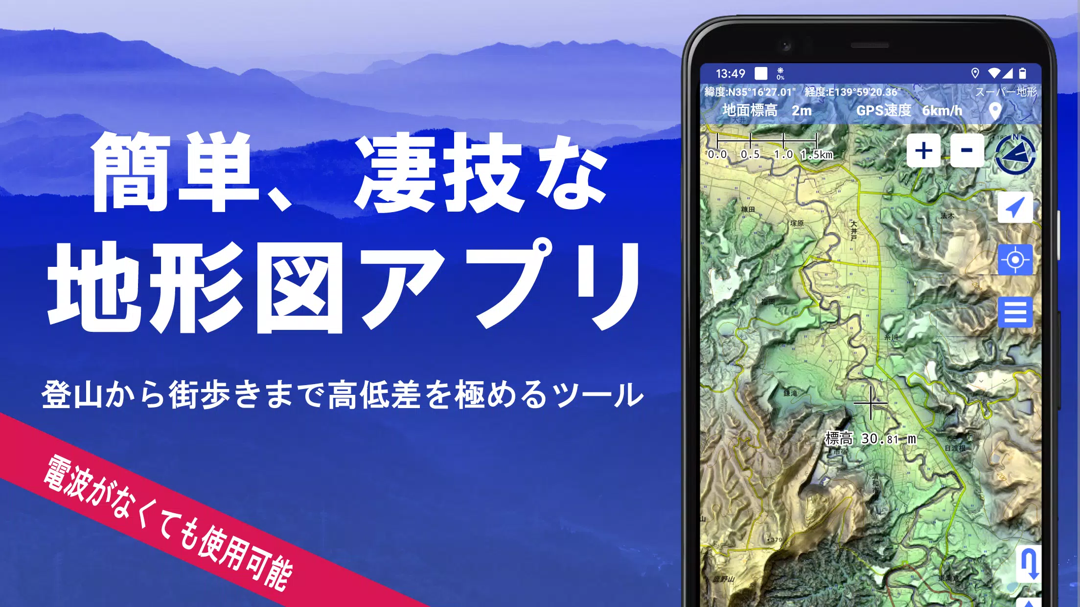
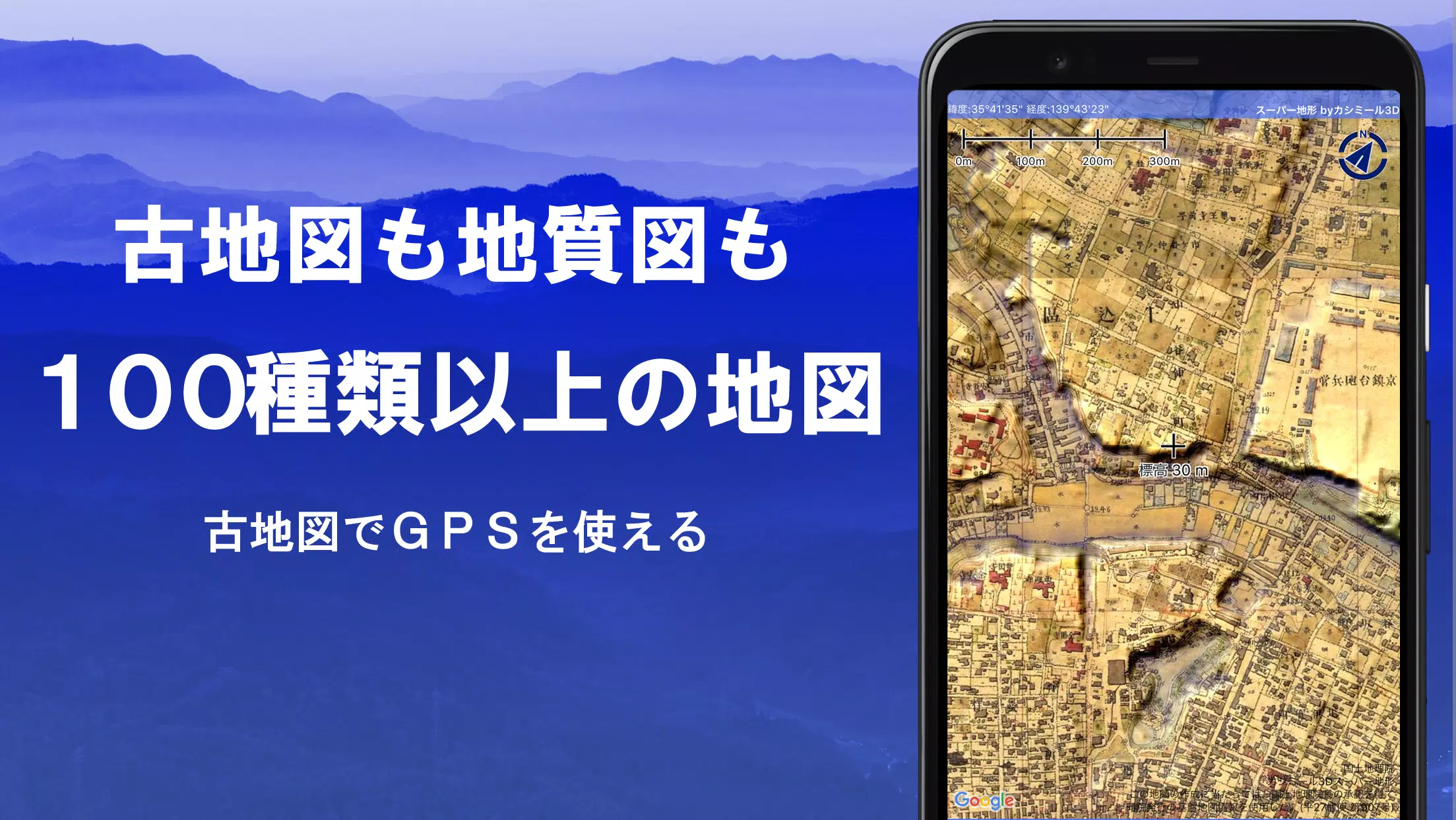
Explore over 100 types of maps with Super Terrain, including detailed offerings from the Geographical Survey Institute. From mountain climbing to leisurely strolls around town, these maps maximize the utility of terrain differences, enhancing your outdoor experience. Super Terrain was honored with the 2018 Japan Cartographic Society Award for Best Work, a testament to its excellence.
Leverage Super Terrain's unique "super terrain data" to emphasize topographical features. You'll have access to a variety of maps from the Geospatial Information Authority of Japan, including topographic, geological, historical, and prewar Ordnance Survey maps. Use the GPS function to record your tracks, with GPX log input/output and editing capabilities at your fingertips.
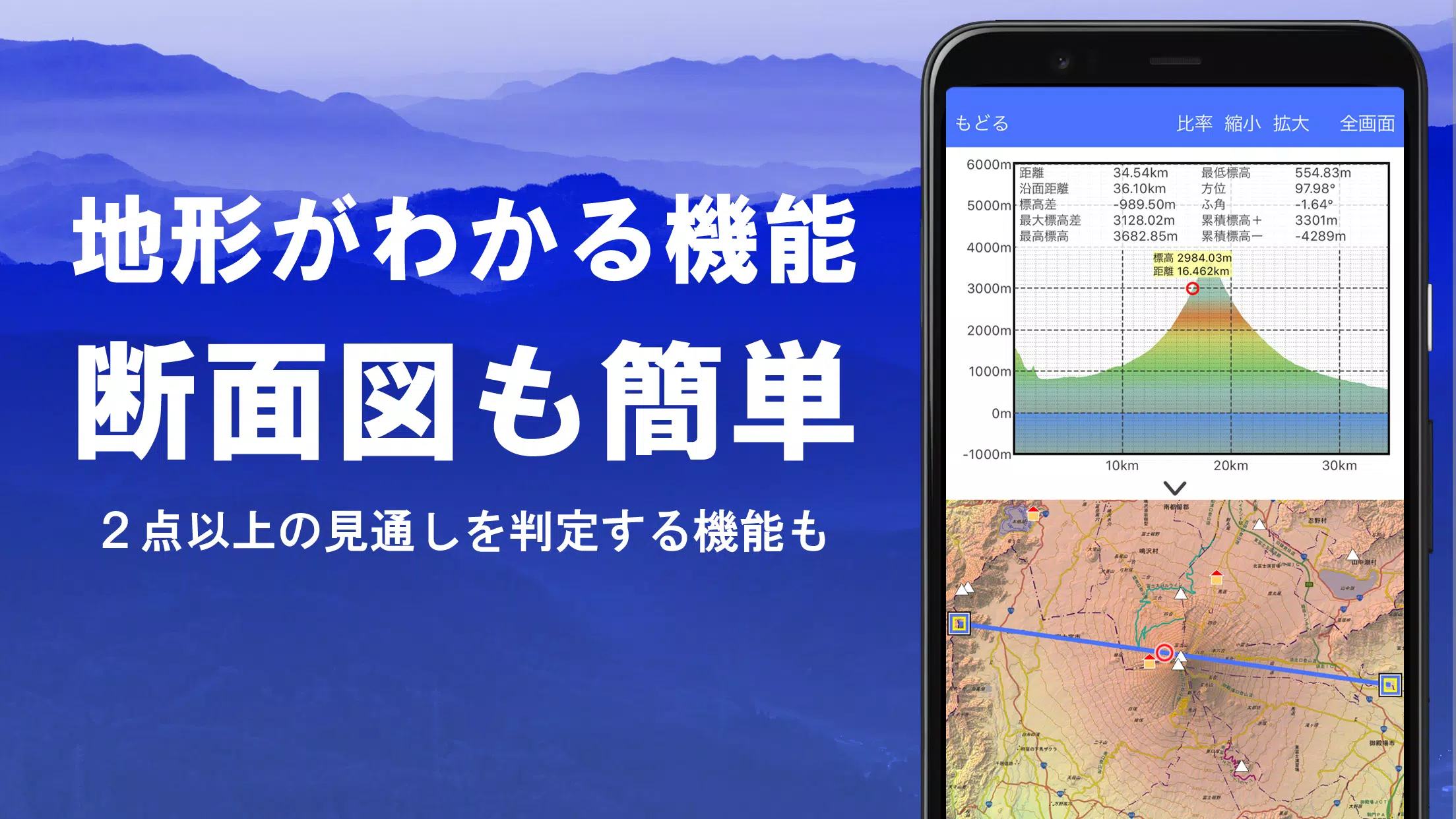
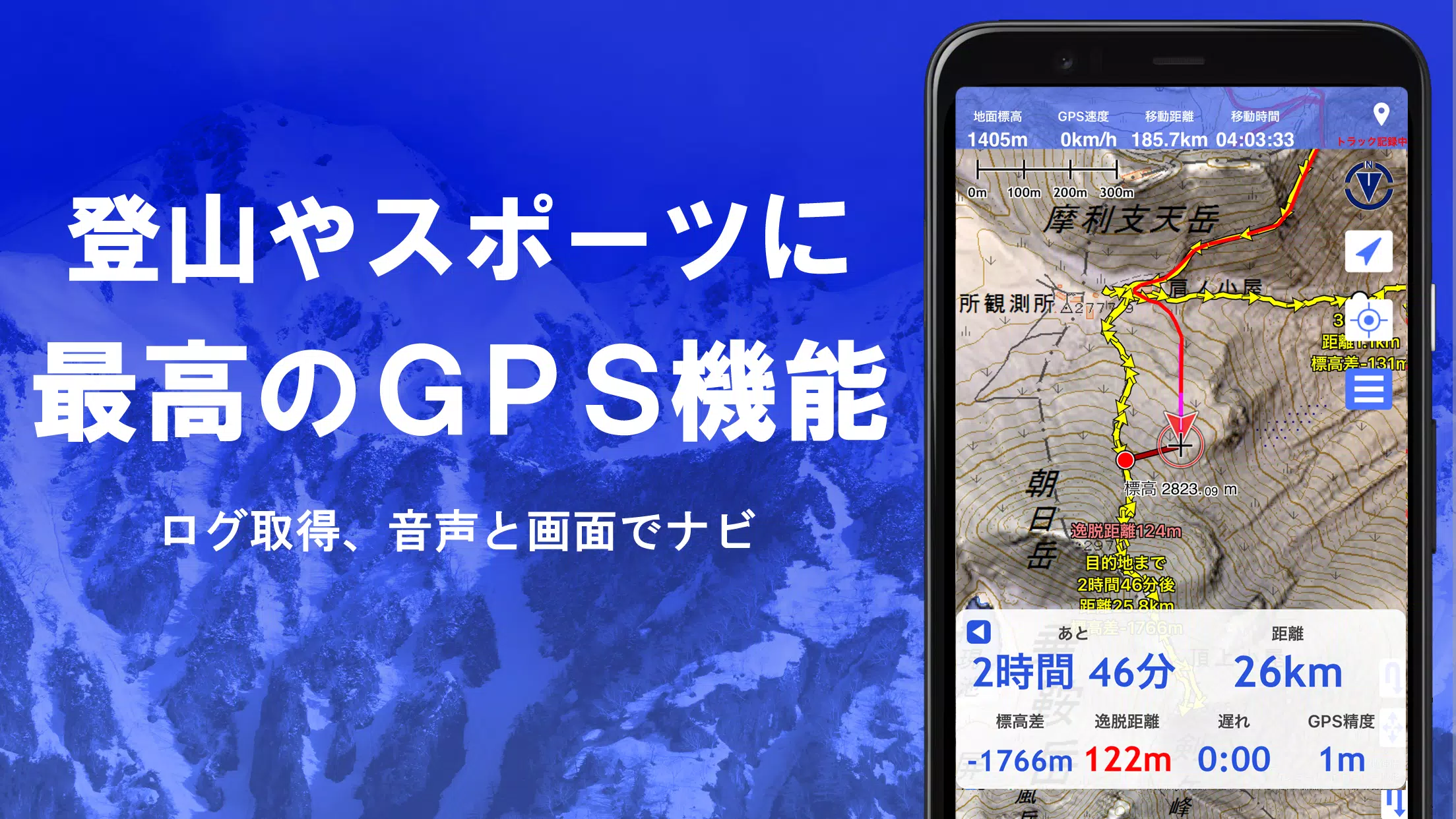
Super Terrain is designed to support your adventures, from navigating urban areas to conquering mountain peaks. Features include GPS navigation with audio cues, data recording, and editing. Additionally, the visibility determination function aids in creating cross-sectional diagrams and assessing observation and radio conditions, while also displaying buildings.
Experience a 360° panoramic view function to identify mountains by name and track celestial bodies like the sun and moon, along with your GPS points. Enjoy seamless offline use with bulk map downloads and a map cache, perfect for when you're out of signal range during your outdoor escapades. You can also associate photos with specific points and visualize contour lines generated from elevation data.
Super Terrain supports the MGRS grid (UTM grid) and allows you to read, display, and edit GIS data from GeoJSON files. Draw shapes, use the app overseas, print maps, or output them as PDFs. The app also features a dark theme for comfortable viewing.
1. A Wealth of Maps at Your Fingertips
With over 100 types of maps, including combinations, Super Terrain offers its proprietary super topographic data alongside maps from the Geospatial Information Authority of Japan and hazard maps. Note that aerial photographs may not be available for all areas, with "Latest" and "around 1974" having the broadest coverage. You can enjoy a free 5-day trial of maps using super terrain data upon installing the app.
2. Creating Cross Sections and Outlooks
Easily draw cross-sections through any point on the map with Super Terrain. The app includes a visibility judgment function, considering Earth's curvature and atmospheric differences, ideal for route planning during climbs, assessing wireless visibility, and understanding terrain. In areas with PLATEAU building data, you can incorporate buildings into your cross-sectional views.
3. Elevation Palette Function
Customize your map's appearance with the elevation palette function, adjusting the background color to your preference in 1cm increments.
4. Panoramic View
Identify mountains from any location with Super Terrain's panoramic observation map. Enjoy a 360-degree panorama linked to your smartphone's compass, perfect for mountain identification. View the sun and moon, including moon phases, to explore phenomena like Diamond Fuji and Pearl Fuji. Additionally, you can view GPS point locations and draw panoramic views of overseas mountains.
5. GPS Function
Utilize your smartphone's GPS to obtain location information and record tracks with high-precision measurements suitable for serious mountain climbing and outdoor activities. Visualize your tracks with parameters such as elevation, speed, time, and elapsed time. The point alarm function alerts you with voice and sound as you approach specific points. Display photos linked to points and send the map center position to NaviCon.
6. GPS Track Summary Playback
Replay your entire track with the GPS track summary playback feature. The app automatically matches and displays photos taken during your journey, with icons indicating photo locations that you can view by tapping.
7. GPS Navigation Function
Navigate along preset tracks with the Track Navi function, using your smartphone's GPS. Voice and alarm notifications alert you if you stray from the track, ensuring you stay on course during climbs. Additionally, use route navigation for urban walks or point navigation to reach a specific destination.
8. GPS Data Editing Function
Manage GPS-related point, route, and track data within Super Terrain. Organize data into folders displayed in an easy-to-read tree format. Create tracks directly on the map and import/export data in GPX format from climbing websites.
9. Map Usage Outside the Service Area (Offline)
Use maps even in signal-less areas like mountains with Super Terrain's bulk download feature, ensuring you have all necessary scale maps downloaded beforehand. The cache function further enhances offline map usability.
10. Map History Function
Super Terrain remembers your previous map views, allowing you to return to them easily.
11. Custom Map Compatibility
Import custom maps created with Kashmir 3D's map cutter, displaying and utilizing your own maps or scanned images. Divide images into approximately 256 x 256 pixels and send the kmz file to Super Terrain via email or cloud drive.
12. GeoJSON Compatibility
Display and edit points, linestrings, and polygons from GeoJSON format files, and draw new shapes.
13. Print/PDF Output
Print any map area at a specified scale or output it as a PDF.
14. Cooperation with Other Apps
Super Terrain supports data exchange in GPX, KML, and GDB formats, enabling integration with other apps, the Kashmir 3D software on your PC, and trajectory data from climbing sites.
15. Backup Function
Backup all app data (excluding cached maps) and remove it from your smartphone. Restore data even if you delete the app or encounter device issues. An automatic backup feature using Google Drive ensures your data stays up-to-date. For detailed information, refer to the manual.
16. About Billing Function
Certain features, like maps using super terrain data, GPS track functions, and cross-sectional views, require in-app purchases. Post-purchase, you'll see an increase in place name search results. The annual subscription fee is 780 yen/year, with a free 5-day trial upon installation. You won't be charged unless you actively purchase. To buy, navigate to [Settings] - [Purchase to remove functional restrictions] within the app.
Check and cancel automatic updates through Google Play under "Regular Purchase" and select "Super Terrain." Prices may be revised with future enhancements, making early purchase advantageous.
17. Terms of Use
The copyright holder and developer are not responsible for the outcomes of using this application. Upon first use of GPS, allow location services. Continuous GPS use can drain your battery, so carry a spare for emergency communication needs. An explanation of the navigation function is available in PDF format at https://www.kashmir3d.com/online/superdemapp/superdem_navi.pdf. Be aware that some smartphones may interrupt track recording due to power-saving features, a common issue across apps. Keeping Super Terrain active while the screen is off can help, but it's not a permanent solution.


-
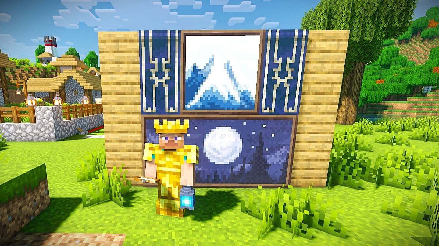 "Minecraft Art Tutorial: Learn to Craft Paintings"
The desire to decorate your own home is not just a real-life aspiration but extends into the virtual world as well. In Minecraft, adding personal touches like paintings can transform your blocky environment into a more vibrant and personalized space. In this article, we'll guide you through the proc
Apr 28,2025 -
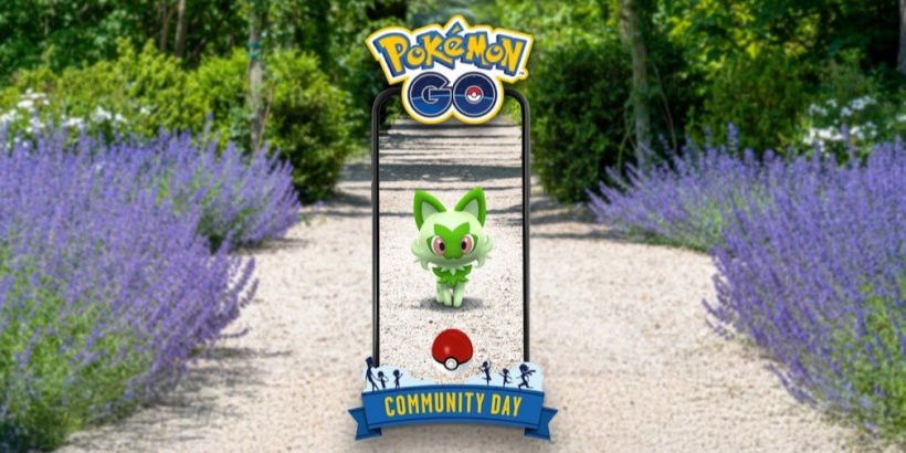
 Pokémon Day 2025: What to Expect
Get ready to celebrate Pokémon Day 2025, an exciting day packed with events for trainers around the globe! This year marks the 29th anniversary of the beloved franchise, and there's plenty to look forward to. Here's a comprehensive guide to the event's schedule, platforms, and the latest announcemen
Apr 28,2025 - ◇ Minecraft Movie's Funniest Scene Inspired by The NeverEnding Story Apr 28,2025
- ◇ Cthulu Keeper: New PC Game Announced Apr 28,2025
- ◇ Fast Ways to Earn Coins in Necesse Apr 28,2025
- ◇ Stellar Blade PC Release Set for 2025 Apr 28,2025
- ◇ Minecraft Unveils Official Hello Kitty DLC Apr 28,2025
- ◇ "Escape from Tarkov to Get DLSS 4 Upgrade" Apr 28,2025
- ◇ Monster Hunter Wilds Beta Extended 24 Hours Post-PSN Outage Apr 28,2025
- ◇ Margaret Qualley Joins Death Stranding Cast After Bizarre Perfume Ad Dance Apr 27,2025
- ◇ The Battle of Polytopia Brings a New Game Mode Called Weekly Challenges Apr 27,2025
- ◇ Join Warhammer 40K Space Marine 2 Public Test: Steps Revealed Apr 27,2025


- 1 Holiday Thief Arrives in Seekers Notes Dec 26,2024
- 2 Jujutsu Kaisen Phantom Parade: Tier List Update for 2024 Dec 28,2024
- 3 How To Find and Beat the Storm King in LEGO Fortnite Jan 05,2025
- 4 PUBG Mobile's Championship Finale Nears Jan 09,2025
- 5 Goddess Of Victory: Nikke Is Dropping a New Year’s Update and Collabs with Evangelion and Stellar Blade Soon Jan 04,2025
- 6 Blue Archive introduces new story event with the Cyber New Year March Jan 05,2025
- 7 Brok's Festive Adventure Now Available Jan 03,2025
- 8 Skibidi Toilet DMCAs Garry's Mod But Legitimacy Remains Unclear Jan 07,2025


-
Mastering the Art of Digital Tools
A total of 10
-
Hidden Gems: Unexpectedly Useful Other Apps
A total of 10
-
Top Free Adventure Necessary Games for Android
A total of 4