2GIS: Offline map & navigation
- Maps & Navigation
- 6.44.1.559.3
- 180.4 MB
- by 2gis
- Android 6.0+
- Apr 27,2025
- Package Name: ru.dublgis.dgismobile
2GIS is your ultimate navigation and city exploration tool, offering offline maps, GPS navigation, live traffic updates, parking information, transit routes, and much more. Whether you're driving, walking, or using public transport, 2GIS ensures you never get lost, even without an internet connection, thanks to its downloadable maps.
With 2GIS, navigating unfamiliar places feels like being at home:
- Easily locate addresses, businesses, phone numbers, operating hours, products, or services.
- Discover how to reach your destination by car, bus, subway, or follow pedestrian navigation.
- Find building entrances and nearby parking lots effortlessly.
Our maps are meticulously detailed, helping you pinpoint districts, buildings, streets, bus stops, subway stations, gas stations, sports facilities, and more.
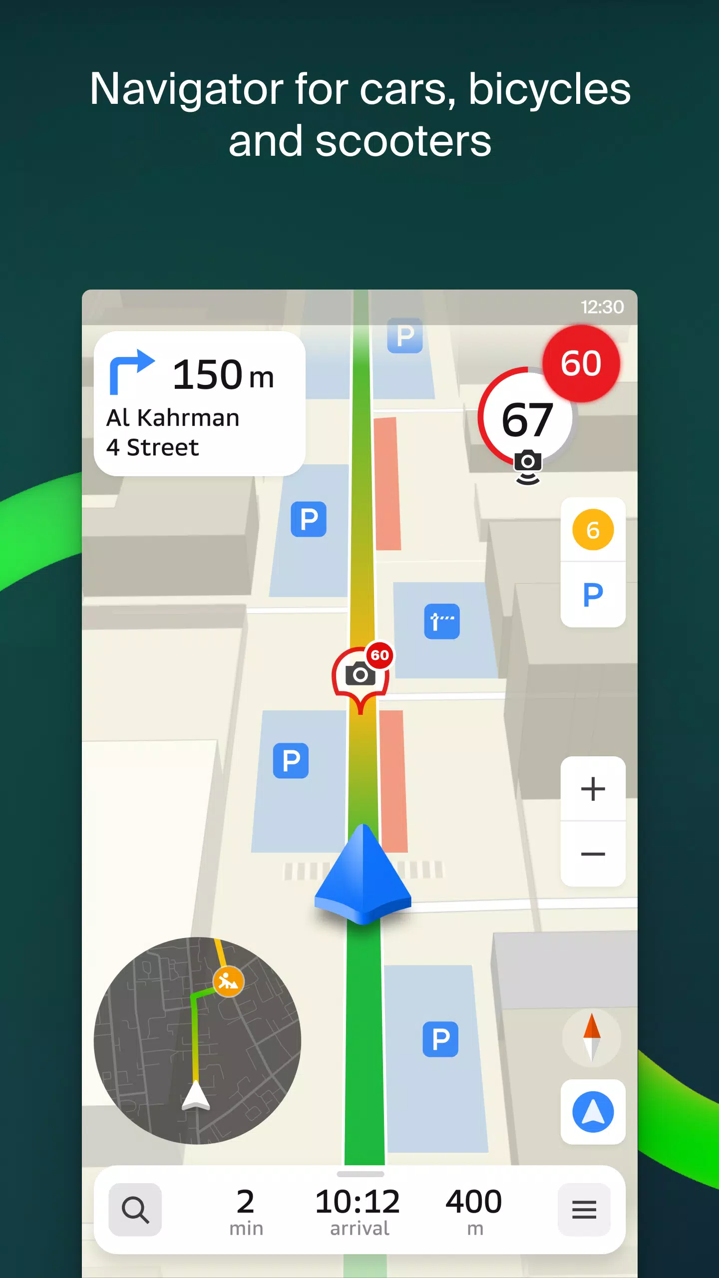
2GIS's GPS navigation system takes into account real-time traffic conditions, road signs, speed cameras, toll roads, and unpaved routes. It can plot routes between cities and through multiple points. Plus, there's a free app compatible with Android Auto.
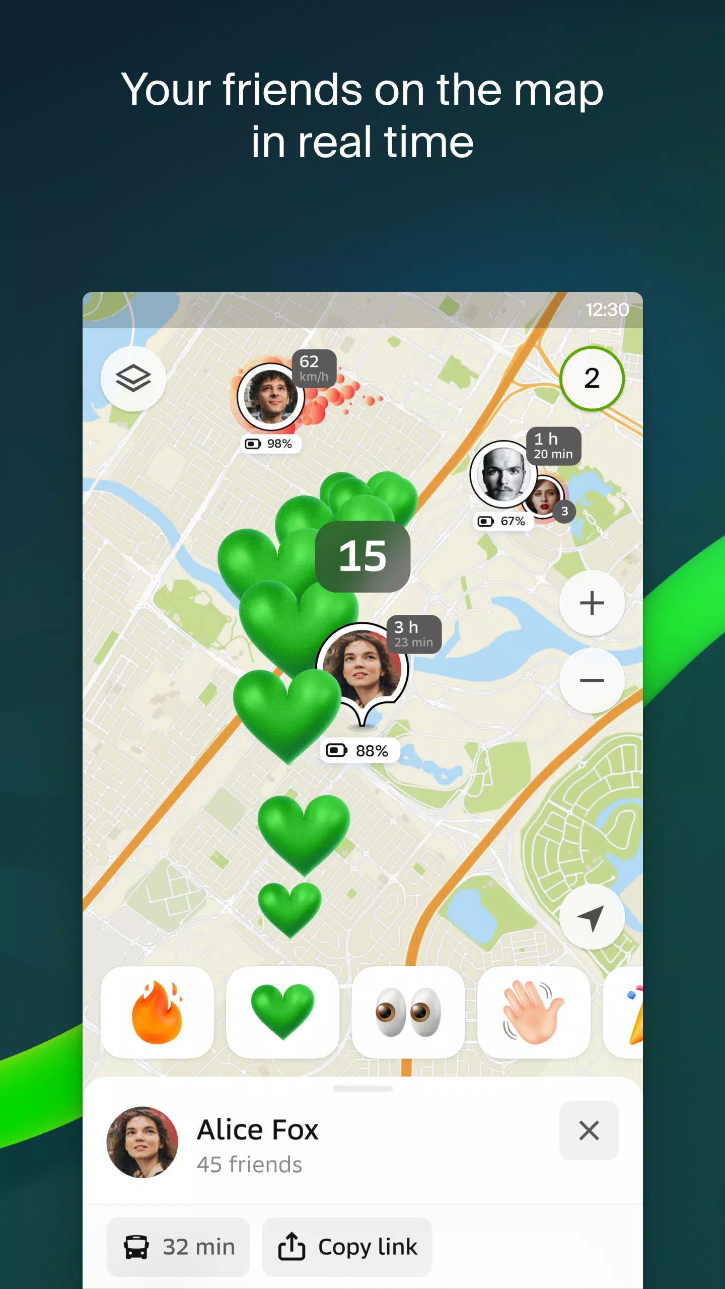
Stay connected with loved ones using the live friends' location feature on the map. Track your kids or friends for safety, send fun stickers, and check their battery levels. You control who can see your location and can adjust sharing settings at any time.
Stay informed with real-time road event updates, including accidents, blocked streets, and speed camera locations, all directly on the map.
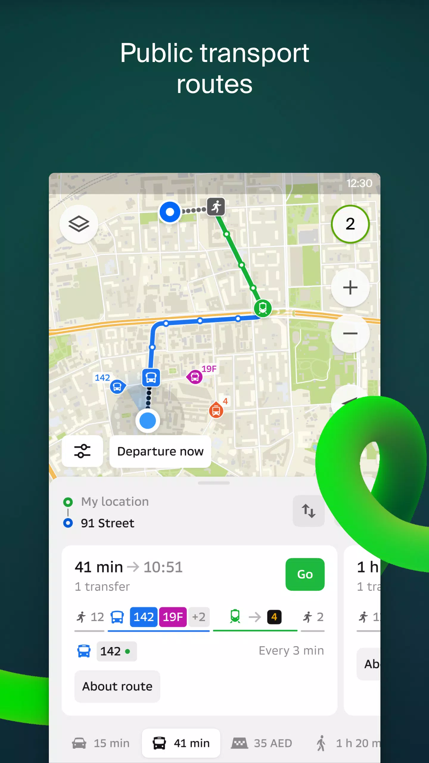
For public transport users, 2GIS provides up-to-date timetables and online routes, ensuring you're always on time.
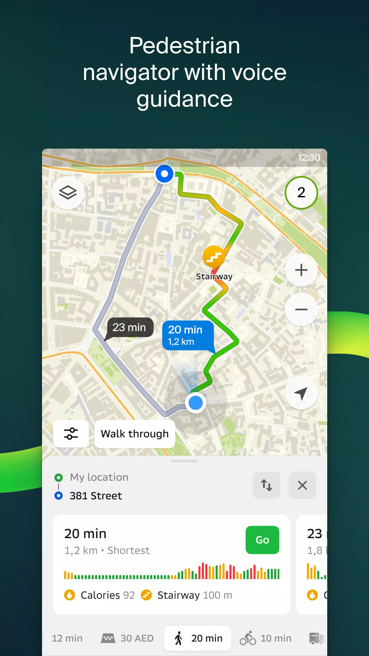
Pedestrian navigation guides you on foot, offering background operation and voice guidance for a seamless experience.
Truck drivers benefit from specialized navigation that considers vehicle and cargo specifics for optimal routing.
Our detailed directory includes addresses, entrances, postal codes, phone numbers, operating hours, social media links, websites, and entrance locations. Users can contribute by adding photos and reviews of businesses.
Explore like a local with our travel guide, which highlights main attractions, Wi-Fi spots, and more on the map.
For smartwatch users, the 2GIS Notifications companion app on Wear OS 3.0 or later versions offers a convenient way to navigate routes on foot, by bike, or public transport. It displays maps, provides maneuver hints, and sends vibration alerts when approaching turns or destination bus stops, automatically syncing with your phone's navigation.
Available maps cover cities in the UAE, Russia, Belarus, Kazakhstan, Uzbekistan, Azerbaijan, and Kyrgyzstan, including Dubai, Moscow, Minsk, Almaty, and many more.
For any support, reach out to us at [email protected].


-
Margaret Qualley Joins Death Stranding Cast After Bizarre Perfume Ad Dance
Hideo Kojima has revealed that he cast Margaret Qualley in the role of Mama in Death Stranding after being captivated by her performance in a Spike Jonze-directed fragrance advertisement for Kenzo. In a tweet dated April 25, Kojima shared the viral commercial, stating, "I saw this and offered her th
Apr 27,2025 -
 The Battle of Polytopia Brings a New Game Mode Called Weekly Challenges
The Battle of Polytopia has just rolled out an exciting new feature with the introduction of Weekly Challenges, adding a fresh competitive edge to this beloved 4X strategy game. Let's dive into the details and see how this update can elevate your gaming experience.It Was Random BeforeIn the world of
Apr 27,2025 - ◇ Join Warhammer 40K Space Marine 2 Public Test: Steps Revealed Apr 27,2025
- ◇ Supercell Hires for Film and TV: Clash of Clans Movie in the Works? Apr 27,2025
- ◇ SteelSeries Arctis Nova Pro: Best Wireless Gaming Headset Now 25% Off Apr 27,2025
- ◇ "Varenje: Don’t Touch Berries - Shrink to Bug Size, Quest for Normalcy Now in Pre-Registration" Apr 27,2025
- ◇ "Shining Revelry: All Pokemon TCG Pocket Cards Revealed" Apr 27,2025
- ◇ Dragon Soul Tier List: Ultimate Guide Apr 27,2025
- ◇ The Nvidia GeForce RTX 5070 Ti Graphics Card Is in Stock on Amazon (for Prime Members) Apr 27,2025
- ◇ April 2025: Latest Redeem Codes for Black Russia Apr 27,2025
- ◇ Anthony Mackie Confirmed as MCU's Permanent Captain America Apr 27,2025
- ◇ Duskbloods Exclusive Release on Nintendo Switch 2 Apr 27,2025


- 1 Holiday Thief Arrives in Seekers Notes Dec 26,2024
- 2 Jujutsu Kaisen Phantom Parade: Tier List Update for 2024 Dec 28,2024
- 3 How To Find and Beat the Storm King in LEGO Fortnite Jan 05,2025
- 4 PUBG Mobile's Championship Finale Nears Jan 09,2025
- 5 Goddess Of Victory: Nikke Is Dropping a New Year’s Update and Collabs with Evangelion and Stellar Blade Soon Jan 04,2025
- 6 Blue Archive introduces new story event with the Cyber New Year March Jan 05,2025
- 7 Brok's Festive Adventure Now Available Jan 03,2025
- 8 Skibidi Toilet DMCAs Garry's Mod But Legitimacy Remains Unclear Jan 07,2025


-
Mastering the Art of Digital Tools
A total of 10
-
Hidden Gems: Unexpectedly Useful Other Apps
A total of 10
-
Top Free Adventure Necessary Games for Android
A total of 4