AlpineQuest Explorer Lite
- Travel & Local
- 2.3.8d
- 8.0 MB
- by Psyberia
- Android 2.1+
- Apr 28,2025
- Package Name: psyberia.alpinequest.free
Turn your phone into a real off-road GPS using offline topo maps with AlpineQuest, the ultimate companion for all your outdoor adventures. Whether you're into hiking, running, trailing, hunting, sailing, geocaching, or off-road navigation, AlpineQuest has you covered.
No advertisements ~ No data sharing & monetization ~ No analytics ~ No third party libraries
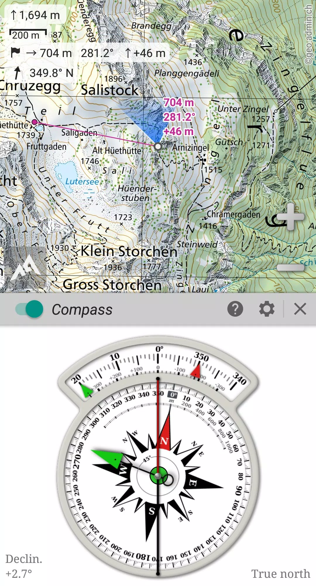
With AlpineQuest, you can access and store a wide range of online topographic maps locally, ensuring they remain available even when you're out of cell coverage. The app also supports numerous on-board file-based raster map formats, making it versatile for all your mapping needs.
Leveraging your device's GPS and magnetic sensor, AlpineQuest ensures real-time localization on the map. The map can also be oriented to align with your current view, making navigation intuitive and straightforward. Say goodbye to getting lost!
Save and retrieve an unlimited number of placemarks, and share them with friends. Track your path, access advanced statistics, and view interactive graphics to enhance your outdoor experience. With AlpineQuest, you'll have all the tools you need at your fingertips.
Designed to be fully operational without cell coverage, AlpineQuest is perfect for exploring the deep wilderness. Whether you're in the mountains or abroad, this app will assist you in all your adventures.
Don't hesitate, try the Lite version for free right now!
For suggestions or issues, please use our dedicated forum at https://www.alpinequest.net/forum (no registration required, all questions answered) instead of leaving comments.
Key features include (for the full version):
★★ Maps ★★
• Access built-in online maps with automatic local storage, including road, topo, and satellite maps, along with online layers like road names, hillshade, and contours.
• Easily add more online maps and layers from the included community maps list, covering all major worldwide and many local topo maps.
• Store complete areas of online maps for offline use.
• Support for on-board offline maps (raster) such as KMZ Overlays, OziExplorer OZFx2, OZFx3 (partly), calibrated images, GeoTiff, GeoPackage GeoPkg, MbTile, SqliteDB, and TMS zipped tiles. Visit our website to download MOBAC, the free map creator.
• Compatibility with QuickChart Memory Map (.qct maps only, .qc3 maps not supported).
• Use any scan or picture as a map with the built-in image calibration tool.
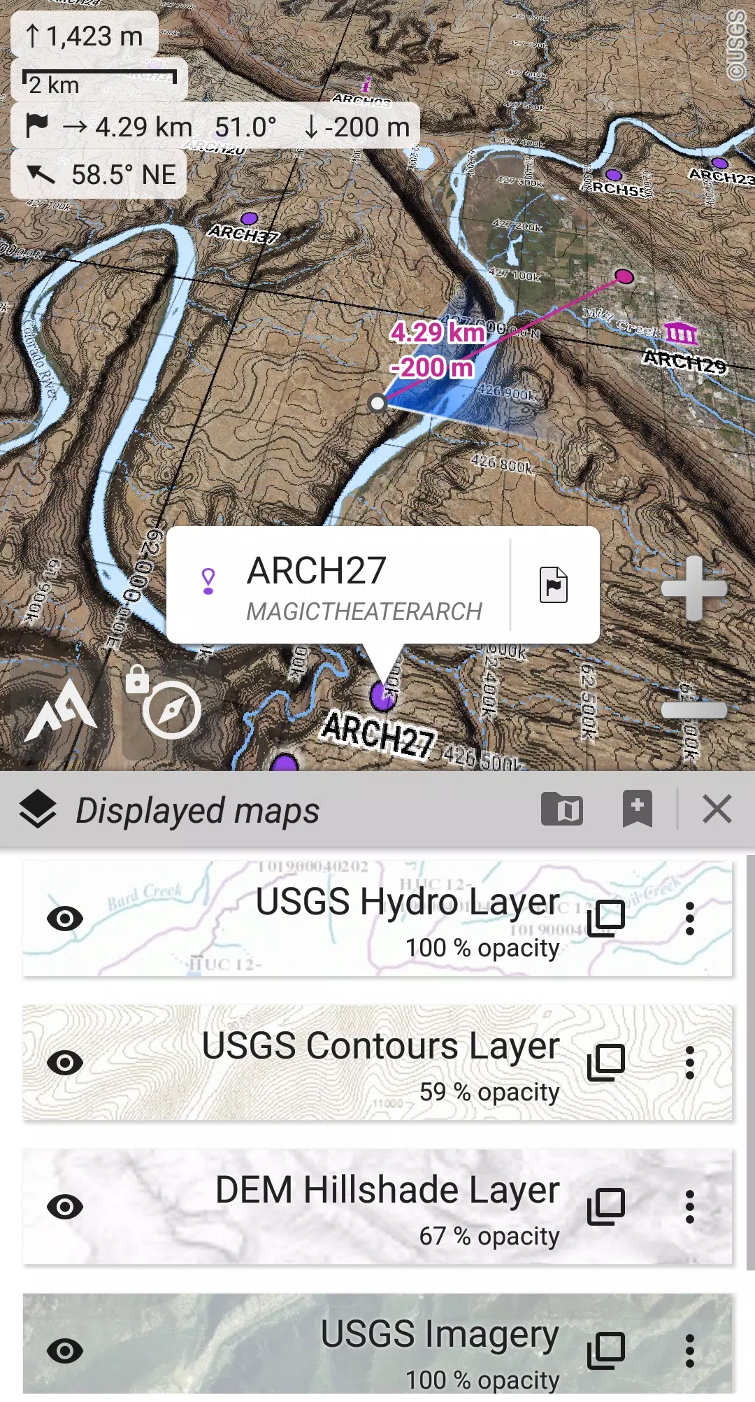
• Store digital elevation models (1-arcsec SRTM DEM) on-board and support for HGT elevation files (1-arcsec and 3-arcsec resolutions) to display terrain, hillshade, and steep slopes.
• Support for polar maps (Arctic and Antarctic).
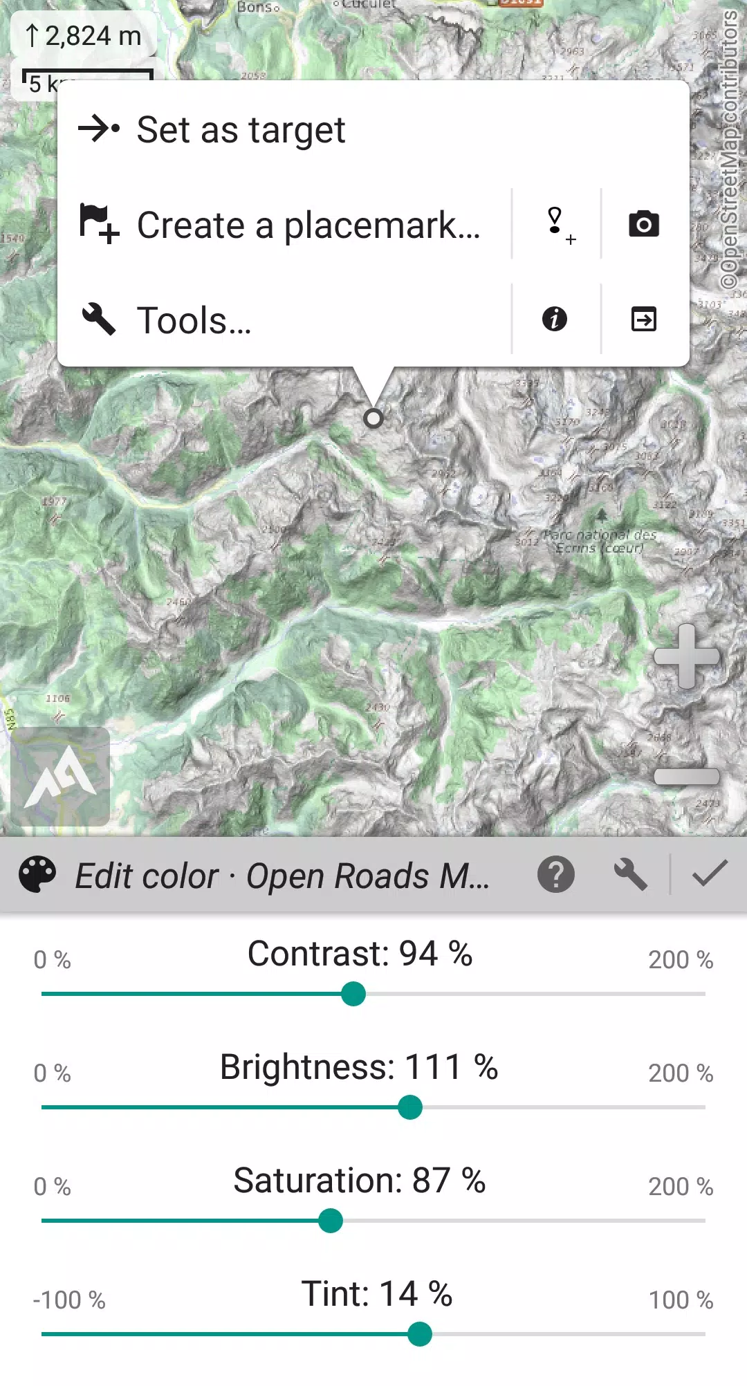
• Display multiple maps in layers with control over per-map opacity, contrast, color, tint, and blending.
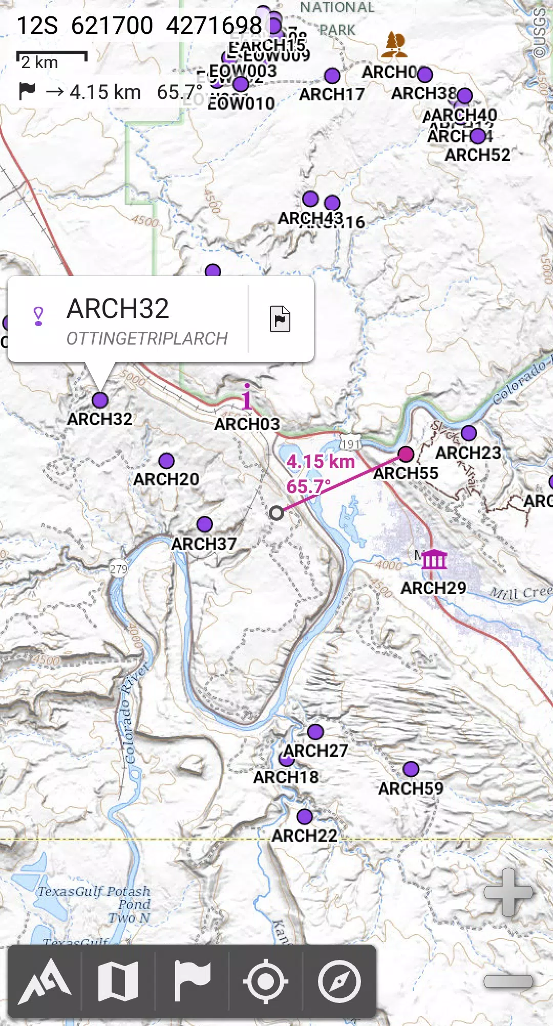
★★ Placemarks ★★
• Create, display, save, and restore an unlimited number of items including waypoints, routes, areas, and tracks.
• Import and export GPX files, Google Earth KML/KMZ files, and CSV/TSV files.
• Import ShapeFile SHP/PRJ/DBF, OziExplorer WPT/PLT, GeoJSON, IGC tracks, Geocaching LOC waypoints, and export AutoCAD DXF files.
• Save and share online locations with other users using Community Placemarks.
• Access details, advanced statistics, and interactive graphics for various items.
• Use the Time Controller to replay time-tagged tracks.
★★ GNSS Position / Orientation ★★
• Utilize on-map geolocation with your device's GNSS receivers (GPS/Glonass/Galileo/…) or network.
• Benefit from map orientation, compass, and target finder features.
• Use the built-in GNSS/Barometric track recorder for long tracking, with battery level and network strength recording.
• Set up proximity alerts and leave path alerts.
• Enjoy barometer support on compatible devices.
★★ And more ★★
• Choose from metric, imperial, nautical, and hybrid distance units.
• Use latitude/longitude and grid coordinate formats (WGS, UTM, MGRS, USNG, OSGB, SK42, Lambert, QTH, …) with on-map grids display.
• Import hundreds of coordinate formats from https://www.spatialreference.org.
• …
What's New in the Latest Version 2.3.8d
Last updated on Aug 14, 2024
2.3.8b/c/d
• Added a new setting to customize the display style and side of the menu bar.
• Enhanced support for recent Android versions.
• Improved the backup and restore tool.
• Updated the default URL for sharing coordinates as text.
• Added the ability to set the application's “Media” folder as the default for placemarks, icons, pictures, and file-based maps.
• Included Croatian and Persian translations.
• Implemented various improvements and bug fixes.


-
 Crime and Punishment System in Kingdom Come: Deliverance 2 Explained
In *Kingdom Come: Deliverance 2*, crime is more than just a minor hiccup—it's a significant element that can drastically alter how the game world reacts to your actions. Whether you're caught stealing, trespassing, or even assaulting someone, the consequences can be severe. Here’s a comprehensive lo
Apr 28,2025 -
 Discover the Lower Semine Woodcutters’ Treasure in Kingdom Come Deliverance 2
In *Kingdom Come: Deliverance 2*, treasure hunting is an exciting part of the game, with many cryptic maps leading to hidden riches. If you're on the hunt for the Lower Semine woodcutters' treasure, follow this guide to uncover the secrets and claim your reward.Finding the Lower Semine Woodcutter’s
Apr 28,2025 - ◇ Pokemon GO Reveals 2025 Lunar New Year Event Apr 28,2025
- ◇ "Grand Summoners Announces Rurouni Kenshin Crossover Event" Apr 28,2025
- ◇ Hearthstone Launches Year of the Raptor with New Content Apr 28,2025
- ◇ Sapphire Nitro+ RX 7900 XTX Below MSRP: Limited Time Offer Apr 28,2025
- ◇ "Locate Cumans' Camp in Kingdom Come Deliverance 2: Invaders Quest Guide" Apr 28,2025
- ◇ Sony Pulls First-Party PS3 Games Resistance: Fall of Man and Resistance 2 From PS5 and PS4 as Part of Big PS Plus Clearout Apr 28,2025
- ◇ Amazon Slashes Prices: Buy One Board Game, Get One 50% Off Apr 28,2025
- ◇ GameStop Slashes Prices: Super Mario RPG, Dragon Age Now $25 Apr 28,2025
- ◇ "Switch 2's New C Button Unveiled Before Direct" Apr 28,2025
- ◇ SK Hynix P41 Platinum: Fast 2TB M.2 SSD Now More Affordable Apr 28,2025


- 1 Holiday Thief Arrives in Seekers Notes Dec 26,2024
- 2 Jujutsu Kaisen Phantom Parade: Tier List Update for 2024 Dec 28,2024
- 3 How To Find and Beat the Storm King in LEGO Fortnite Jan 05,2025
- 4 PUBG Mobile's Championship Finale Nears Jan 09,2025
- 5 Goddess Of Victory: Nikke Is Dropping a New Year’s Update and Collabs with Evangelion and Stellar Blade Soon Jan 04,2025
- 6 What to Do With the Wandering Drunk in Kingdom Come Deliverance 2 Feb 28,2025
- 7 Blue Archive introduces new story event with the Cyber New Year March Jan 05,2025
- 8 Brok's Festive Adventure Now Available Jan 03,2025


-
Mastering the Art of Digital Tools
A total of 10
-
Hidden Gems: Unexpectedly Useful Other Apps
A total of 10
-
Top Free Adventure Necessary Games for Android
A total of 4