Zoom Earth
- Weather
- 3.1
- 28.5 MB
- by Neave Interactive
- Android 8.0+
- Apr 22,2025
- Package Name: com.neave.zoomearth
Zoom Earth is your go-to platform for tracking hurricanes, typhoons, and tropical cyclones in real-time. This interactive weather map of the world provides a comprehensive suite of features to keep you informed about global weather conditions.
Key Features
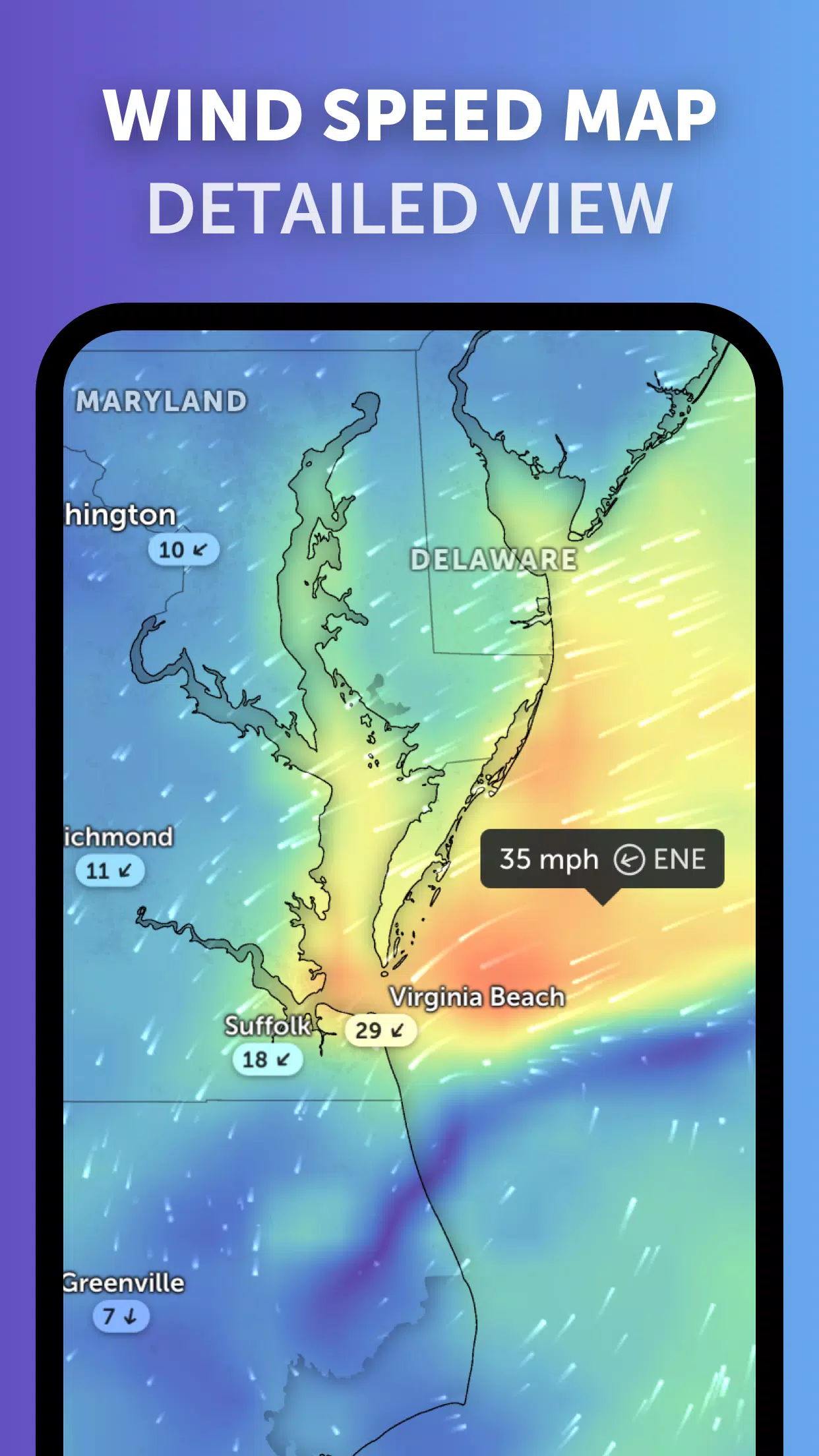
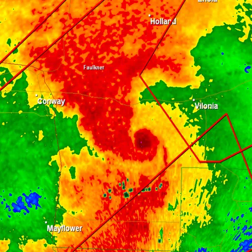
Satellite Imagery: Zoom Earth utilizes near real-time satellite imagery from leading sources such as NOAA GOES, JMA Himawari, EUMETSAT Meteosat, and NASA's Aqua and Terra satellites. This ensures you have the latest visual data on weather patterns across the globe.
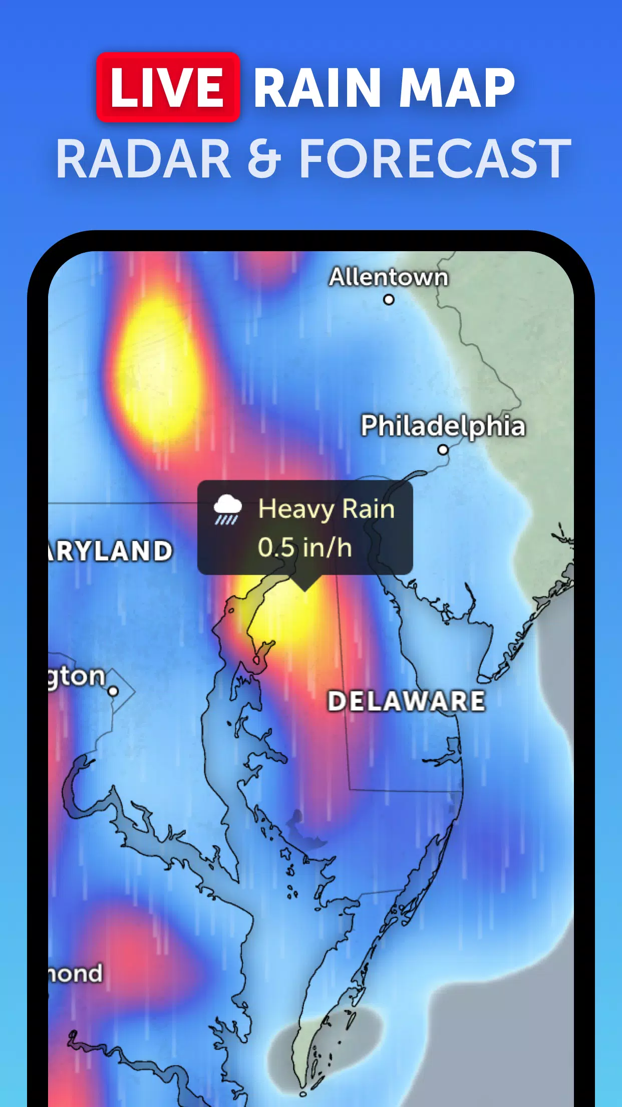
Rain Radar: Stay ahead of the storm with our advanced weather radar map. This tool displays real-time rain and snow data detected by ground-based Doppler radar, helping you anticipate and prepare for incoming weather events.
Weather Forecast Maps: Dive into our visually stunning, interactive weather forecast maps. These maps provide detailed forecasts on precipitation, wind speed and gusts, temperature, "feels like" temperature, relative humidity, dew point, and atmospheric pressure, giving you a complete overview of future weather conditions.
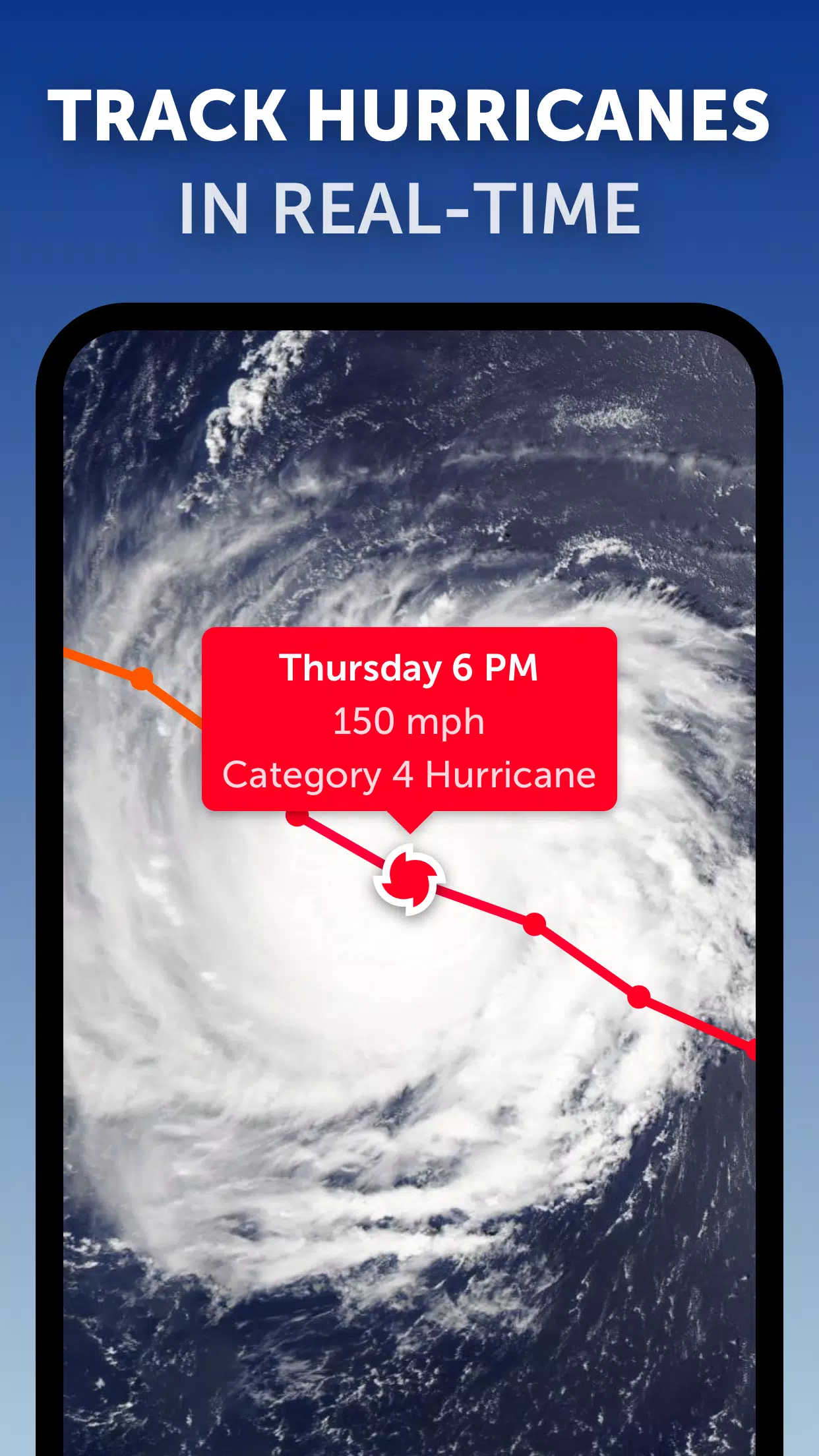
Hurricane Tracking: With Zoom Earth's top-tier tropical tracking system, you can monitor hurricanes from their inception to category 5 status in real-time. We integrate the latest data from NHC, JTWC, NRL, and IBTrACS to ensure you have the most current and accurate information.
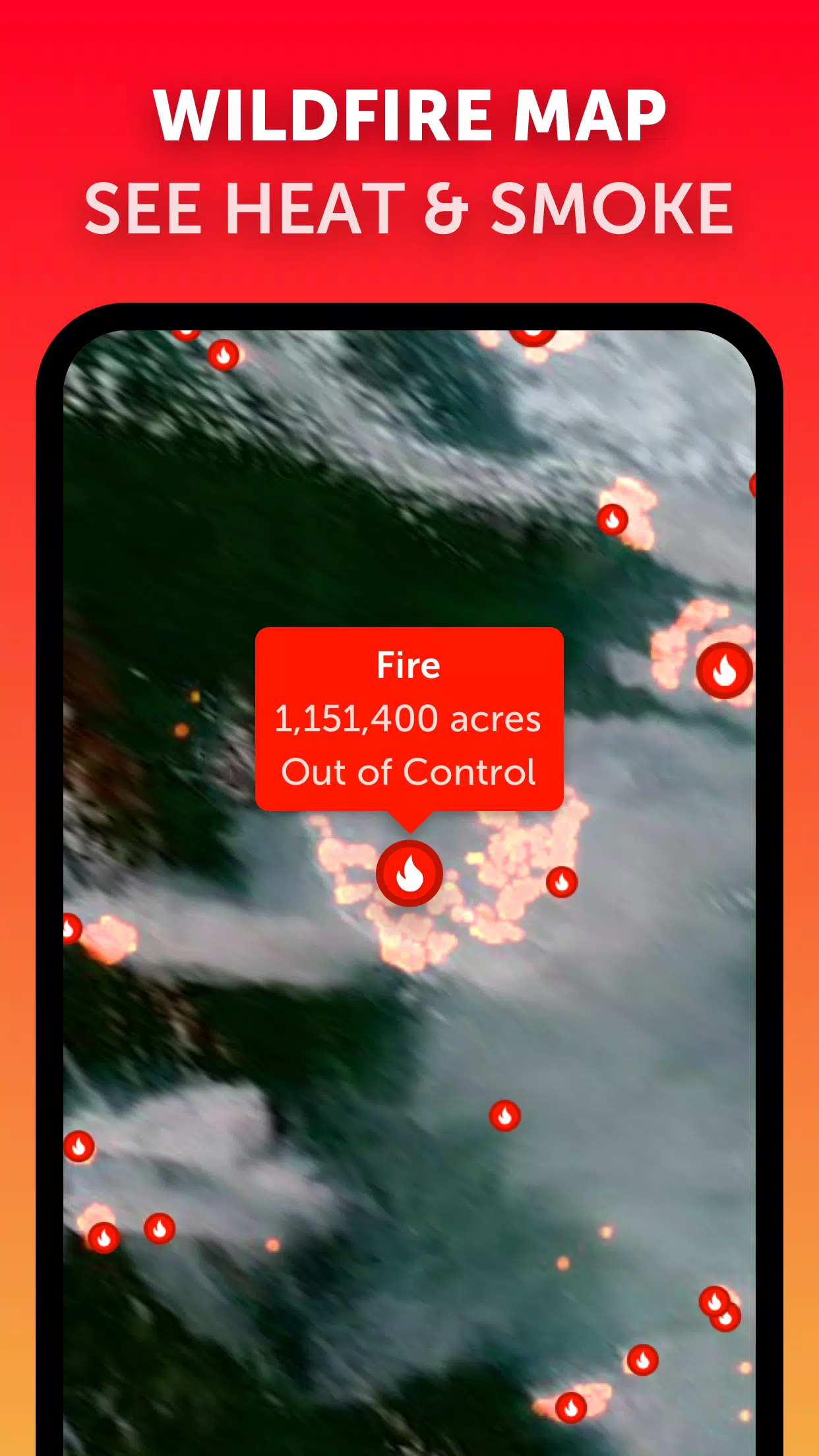
Wildfire Tracking: Keep an eye on wildfires with our active fires and heat spots overlay. This feature uses satellite data from NASA FIRMS, updated daily, to show points of very high temperature, helping you track and understand wildfire activity.
Customization: Tailor your weather experience with our extensive customization options. Adjust temperature and wind units, time zone, animation styles, and more to suit your preferences.
What's New in the Latest Version 3.1
Last updated on Sep 19, 2024
- We've reduced clutter when viewing multiple tropical systems, making it easier to focus on the storms that matter most to you.
- Now, you can receive separate alerts for Atlantic and Eastern Pacific systems, ensuring you stay informed about regional weather threats.
- We've also enhanced our map labels for improved readability and user experience.


-
Ex-PlayStation President on Nintendo Switch 2: 'Expected More, Got Just Enough'
Former Sony Interactive Entertainment Worldwide Studios president Shuhei Yoshida recently shared his candid thoughts on the Nintendo Switch 2's reveal during an interview with Easy Allies. His reaction was less than enthusiastic, highlighting a perceived shift in Nintendo's approach. Yoshida express
Apr 22,2025 -
 "Dune: Part Two Streaming Options for 2025 Revealed"
*Dune: Part Two*, one of the standout blockbusters of 2024, continues to captivate audiences and critics alike. Nominated for Best Picture at the 2025 Oscars, though it deserved even more recognition, the sequel showcases the remarkable vision of director Denis Villeneuve and features a stellar cast
Apr 22,2025 - ◇ New Harry Potter Illustrated Edition Announced, Now Discounted Apr 22,2025
- ◇ inZOI and PUBG will soon have AI-enhanced Co-Playable Characters that can dynamically play with you Apr 22,2025
- ◇ Marvel Rejects AI Use in Fantastic Four Posters Amid Four-Finger Controversy Apr 22,2025
- ◇ Hearthstone Season 10: Trinkets Return to Battlegrounds Apr 22,2025
- ◇ Dynasty Warriors: Origins: Open World Explained Apr 22,2025
- ◇ Season Five Exclusive: The Blossoming Blade in Monster Hunter Now Apr 22,2025
- ◇ "New Game 'League of Puzzle' Combines Match-3 and PvP Battles" Apr 22,2025
- ◇ "Sega Trademarks Suggest Classic Franchise Revival" Apr 22,2025
- ◇ Alicia Silverstone Returns for Clueless Sequel Series Apr 22,2025
- ◇ Tomorrow's Catch-22 Event in Love and Deepspace Features High-Stakes Missions Apr 22,2025


- 1 All the Buttons on Fisch Can Be Found Here Dec 24,2024
- 2 Jujutsu Kaisen Phantom Parade: Tier List Update for 2024 Dec 28,2024
- 3 How To Find and Beat the Storm King in LEGO Fortnite Jan 05,2025
- 4 PUBG Mobile's Championship Finale Nears Jan 09,2025
- 5 Goddess Of Victory: Nikke Is Dropping a New Year’s Update and Collabs with Evangelion and Stellar Blade Soon Jan 04,2025
- 6 Brok's Festive Adventure Now Available Jan 03,2025
- 7 Blue Archive introduces new story event with the Cyber New Year March Jan 05,2025
- 8 Skibidi Toilet DMCAs Garry's Mod But Legitimacy Remains Unclear Jan 07,2025


-
Mastering the Art of Digital Tools
A total of 10
-
Hidden Gems: Unexpectedly Useful Other Apps
A total of 10
-
Top 5 Casual Games for Android
A total of 5